

The Panama Canal has scaled back its daily ship transits from 36 to 32 as of 15 September, as declining rainfall threatens its water supply. At the same time, the Atlantic hurricane season has reached an extraordinary lull, while El Niño is strengthening across the Pacific.
These events are not isolated. They are interconnected through a climate phenomenon capable of influencing weather patterns, food supplies, and global trade. So, what is El Niño? And how can changes in Pacific Ocean temperatures trigger torrential rainfall and devastating floods in some regions while bringing drought and extreme heat to others?
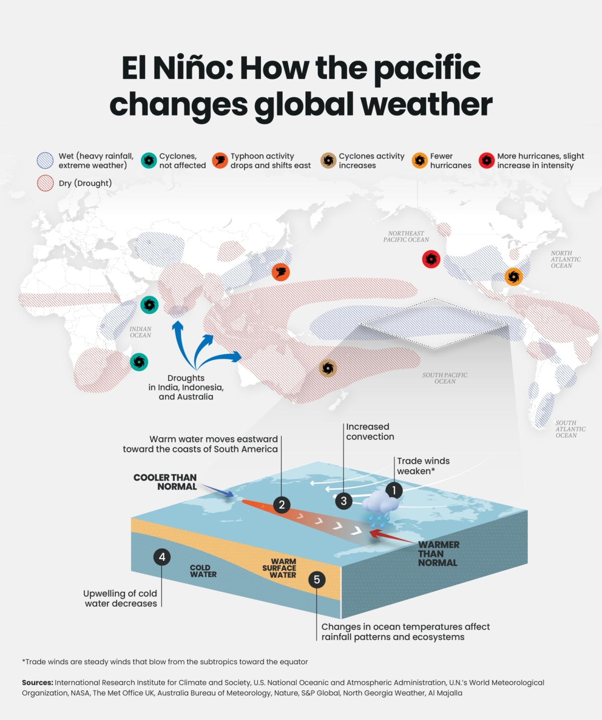
Under normal conditions, trade winds push warm surface water westward toward Indonesia and Australia, while cold, nutrient-rich water rises along the coasts of Peru and Ecuador.
During El Niño, these trade winds weaken, allowing warm water to move eastward across the Pacific. This shifts major rainfall patterns and suppresses the nutrient-rich upwelling off South America. As a result, marine ecosystems can be disrupted, and fish stocks can decline, affecting food supplies, exports and fishing communities.
The stronger the event, the greater the potential for significant disruptions, although its effects vary by region and season. In September 2026, the National Oceanic and Atmospheric Administration (NOAA) said El Niño was strengthening, with more than a 90% chance of becoming a very strong event during the Northern Hemisphere autumn and winter. It also estimated a 75% probability that the October–December event could reach historic strength.
The risks are already shaping outlooks for food production. In Southern Africa, the Food and Agriculture Organisation (FAO) expects below-normal rainfall across much of the region during the 2026/27 agricultural season, threatening maize production and regional cereal supplies. In the Greater Horn of Africa, meanwhile, El Niño is increasing the likelihood of unusually heavy October–December rainfall in parts of Ethiopia, Somalia and Kenya, raising the risk of floods, crop losses and infrastructure damage.
The Atlantic is showing another side of the phenomenon. By mid-September, no hurricanes had formed in the 2026 Atlantic season—an unusually slow start that weather forecasters partly attribute to El Niño’s increased vertical wind shear. At the same time, the phenomenon generally favours greater hurricane activity in the eastern and central Pacific.
Europe offers another reminder of the economic stakes. During summer 2026, exceptionally low flows along the Danube disrupted navigation, irrigation and energy production. The drought cannot be attributed to El Niño alone, but it shows how extreme heat and water shortages can disrupt critical economic infrastructure.